Land & Commercial Media · Central Florida

Aerial Media Built
for Land & Commercial.

From construction progress documentation to interactive 360 panoramas — aerial photography, immersive tours, and property showcases for developers, brokers, and commercial property owners across Central Florida.

Scroll
Services

The Full
REMIX Range

Aerial photography, interactive panoramas, and immersive 3D tours for land, development sites, and commercial properties.

Construction progress aerial photography Central Florida by REMIX
Construction Progress
$250
One-time visit — recurring plans from $200/visit

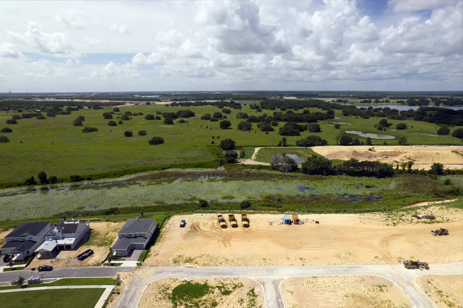
Built for builders. New development moves fast — investors expect updates, lenders want documentation, and your sales team needs content that shows momentum. We work directly with builders and developers as a reliable media partner from groundbreak to grand opening.

Every Visit Includes
  • Cardinal direction views — N, S, E & W coverage at every stage
  • Overhead composite image — top-down high-res site layout view
  • FAA Part 107 certified pilot — fully insured for commercial operations
  • Fast digital delivery — 24–48 hours, formatted and ready to share
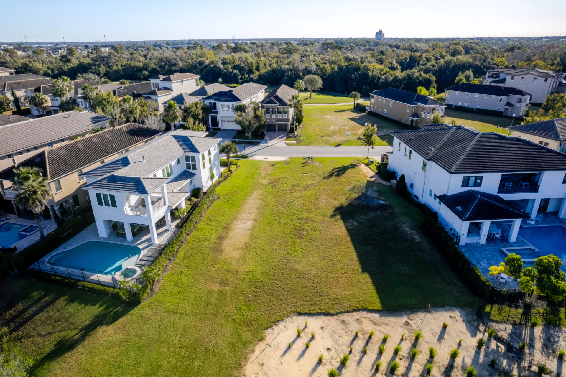
One-Time Visit — $250 — 10–15 drone photos, all deliverables
Weekly Plan — $200/visit — minimum 4 visits
Up to 25 acres included · 26–50 acres contact for pricing · 51+ custom quote
Book Construction Progress
Land and commercial full package aerial photography by REMIX
Land & Commercial Package
$250
Up to 10 acres — larger sites contact for pricing

Reach more buyers with a branded aerial highlight video that shows the full scope — access, layout, surroundings, and potential — in a format that works on MLS, social, and every major listing platform.

Includes
  • 10–15 high-resolution aerial drone photos
  • 1–2 minute aerial highlight video — branded & unbranded
  • Property website & marketing toolkit
  • Lot line overlays on up to 2–3 images (non-official, as requested)
Up to 10 acres $250 · 11–25 acres $350 · 26–50 acres $450 · 50+ contact for quote
Book Full Package
Immersive Experiences

See It From Every Angle

Go beyond still photography. Embed an interactive 360 panorama or a full 3D virtual tour directly into your listing, website, or offering memorandum.

Aerial 360° Panorama Showcase
From $295
Interactive aerial panorama — 12 months hosting included

Location isn’t just a fact — it’s a feeling. This high-resolution, interactive aerial panorama delivers a full-circle view of your property and everything around it. Delivered as a branded, mobile-friendly experience that embeds on your website, drops into MLS, and shares seamlessly across social.

Includes
  • One professionally captured 360° aerial panorama
  • Up to 5 labeled points of interest — parks, dining, schools, shopping
  • Branding and listing information built in
  • Shareable web link and embed code
  • Mobile and desktop optimized · 12 months hosting
  • Click-to-call or contact button
Add-Ons
Additional Labels (+5) — $25
Additional 360° Viewpoint — $100
Teaser Video (15–30 sec) — $125
Hosting Renewal (12 months) — $50
Book Aerial 360 Panorama
3D Virtual Tour
From $250
Fully navigable 3D walkthrough

A fully navigable 3D tour that lets buyers and tenants walk through a commercial space from anywhere in the world. Integrate into MLS, your website, or a dedicated property page.

Includes
  • Full 3D walkthrough tour
  • Shareable link + embeddable iframe code
  • Floor plan schematic view
  • Hosted and mobile-optimized
  • Best for: commercial interiors, showrooms, office space
Book 3D Virtual Tour
Why Aerial

What Aerial
Actually Shows

Not just a better angle. What buyers, investors, and tenants actually need to see before they commit.

🗺
Scale & Context

Aerial photography shows property boundaries, site access, adjacent uses, and surrounding infrastructure in a single frame. No map can replace it.

🏗
Development Progress

Stakeholders and investors need to see the site evolve. Consistent aerial documentation creates a visual record that builds confidence and accountability.

📐
Site Relationships

How far is the nearest highway? What’s the neighboring property? Where does the drainage run? Aerial answers every question a ground-level shot can’t.

🌐
Immersive Exploration

A 360 panorama or 3D tour lets a buyer explore a space from across the country before ever booking a flight. It qualifies prospects and saves everyone’s time.

🏚
Commercial Credibility

High-quality aerial media signals a serious listing. Developers and brokers who invest in professional imagery command better attention from institutional buyers.

📍
Location Storytelling

Where a property sits tells half the story. Proximity to amenities, access roads, visibility corridors — aerial shows what a description can only approximate.

FAQ

Common
Questions

What’s the difference between Aerial Essentials and the Land & Commercial Package?
+

Aerial Essentials is photography only — 10–15 high-res aerial drone photos, a property website, and lot line overlays. It’s the right call for vacant lots and smaller parcels where the aerial tells the whole story. The Land & Commercial Package adds a 1–2 minute branded aerial highlight video, making it the better fit for MLS listings, social media, and investor presentations where motion content performs. Acreage pricing applies to the full package.

How does Construction Progress documentation work?
+

We schedule recurring aerial visits — weekly, bi-weekly, or at project milestones — and deliver consistent cardinal direction views plus an overhead composite after each visit. Everything is delivered to secure cloud storage within 24–48 hours, formatted for investor reports and stakeholder presentations. A one-time visit starts at $250. The weekly plan is $200/visit with a minimum of 4 visits. Coverage up to 25 acres is included; larger sites are priced on request.

How does the Aerial 360° Panorama Showcase work?
+

We capture a high-resolution interactive panorama from the air. You get a shareable link and an embed code — drop it into your listing page, website, or send it directly to prospects. It includes up to 5 labeled points of interest (nearby parks, schools, restaurants, etc.) and is navigable on desktop and mobile with no app required. Hosting is included for 12 months.

Can I combine aerial photography with a 3D tour?
+

Yes — and it’s a powerful combination. The aerial shows the site, the surroundings, and the approach. The 3D tour lets buyers walk the interior. Together they answer almost every question before a showing. Reach out and we’ll put together the right scope and pricing.

Where do you fly?
+

All of Central Florida — Orlando, Winter Garden, Windermere, Lake Nona, Horizon West, Clermont, Kissimmee, and surrounding markets. We also serve the broader Florida market for commercial and development projects. Travel fees may apply outside our primary service area.

Ready to show the full picture?
Let’s Capture the Property.

From a single aerial session to a full immersive package. Book online or reach out to talk through the scope.

Book Online →
Contact

Tell Us About
Your Property

Development site, commercial listing, or land parcel — every project is different. Reach out and we’ll put together the right package.

Send a Message

We respond to every inquiry personally — usually within a few hours.

Direct Contact
Phone
(407) 735-8509
Email
info@rem-ix.com
Service Area
Central Florida & Beyond
Also at REMIX
Listing Photography Video Services Vacation Rental Photography Interior Design Photography
Follow